What is the tell-tale sign of entering a touristy neighborhood in your European city? Tacky souvenir shops at every corner? Crowds? Or a horse carriage nearby waiting for a green traffic light?
What about a map: would you be able to spot a tourist trap just by looking at the city from the bird's view? One might say the clusters of hotels and Airbnb listings might be the dead giveaway. But recently there's been an even more targeted, insidious indicator around, the archenemy of every seasoned traveler: Euronet ATMs.
We've all seen them, and if you've ever had to use one, you'll never forget that whole experience. And where there's one Euronet ATM, you can be sure that the souvenir shops, the crowds, and the horse carriages will follow. So if there's any good from these ATMs, is that they act as clear delineation that you've scrolled a tad too far from your local area and that you are now in the Tourist Zone.
This is what Peter Fabor thought of when he was considering creating a map of ugly mass tourism places. A cluster of Euronet ATMs is easy to spot while searching on Google Maps. But is it just as easy to scrape that map to create a visualization of your own? Anything is, with the right tools. So let's see how he came up with this idea and how he made it happen with Google Maps Scraper.
How to identify ugly mass tourism places before you visit them?
— Peter Fabor (@faborio) November 17, 2023
In Europe, they usually have certain retail stores (e.g. Spar) or bars (Irish pubs).
But one thing defines them very precisely - quantity of Euronet ATMs.
These yellow/blue🟨🟦 ATMs are designed to scam… pic.twitter.com/nsyPSmrDpX
Peter's viral tweet about identifying mass tourism clusters using data
🦾 Web scraping for work and play
Peter knows a thing or two about gentrified touristy neighborhoods. That's because he spends a lot of effort and time trying to avoid them — both for his work and as a personal preference. And who can blame him?
Peter is a digital nomad with experience, now anchored in Amsterdam. His main business, a marketplace for company offsites called Surfoffice, is operating at the intersection of hospitality, real estate, and tech. So since has a lot of general interest in finding the best place for work and living — for himself and others — he has to work smarter, not harder. And web scraping is an integral part of that formula.
For work, he uses scraping in many different ways, either by himself or by hiring help. His business organizes offsites and team building for remote tech companies across Europe, the US, and Central America. A big part of this work is researching specific hotels and vendors in each country. And finding the right venues can be quite a challenge sometimes.
One way scraping helps him out here is through gathering hotel data directly from Booking.com. Another way is scraping a specific area on Google Maps for all the hotels. Scraping even helps him to find the right leads from the job boards. Since the hiring companies usually mention offsites as a perk in job descriptions, it only makes sense to scrape that job description for contact details and contact these companies with an offer. And if both the scraping part and posting a list of contacts part are done automatically, all that is left to do is select the leads, assign them, and start sending emails.
🌆 Side projects with web scraping
But Peter uses web scraping for fun side projects and experiments as well. In fact, his businesses tend to grow out of general interest in locations and data. Such was Hoodpicker which started as a simple survey, then grew into a blog about neighborhoods in Lisbon, and now it's a set of tools for people who want to invest in real estate in Portugal. Being a data-oriented person, Peter made sure web scraping was a part of Hoodpicker as well.
You can see it as a scraped map data bundled together to make it easy to compare neighborhoods by different aspects of life in them. It is useful when you want to move to a new city and you want to do some exploration but don't want to get overwhelmed or distracted by the amount of information. Most of the data used in this project is scraped from public sources combined with some other sources. This made Hoodpicker quite popular among people who want to move to Lisbon or just are considering living there for a while, with 200 people per day using this tool.
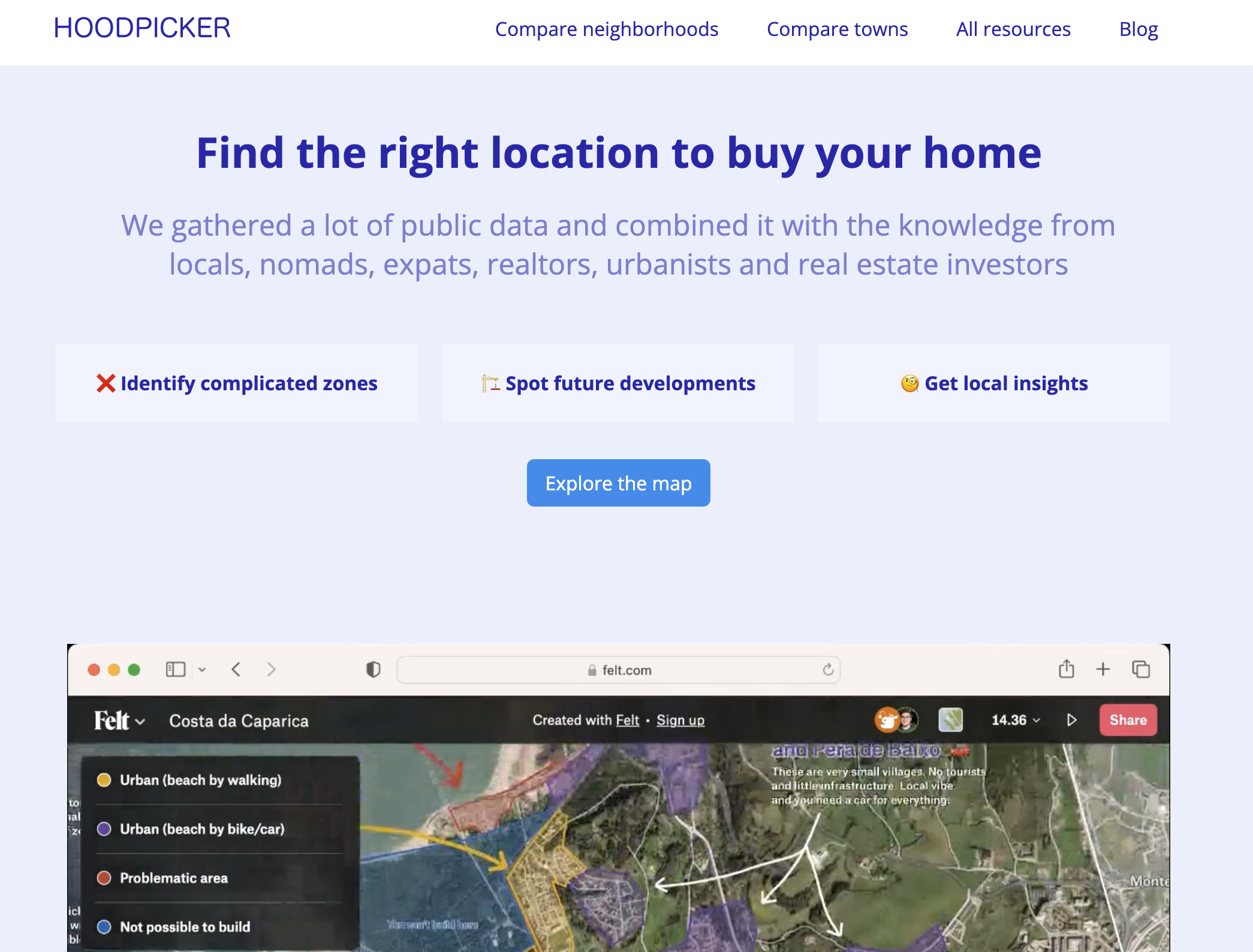
Part of working on Hoodpicker was also answering a question of what makes an area touristy, data-wise. Defining some sort of tourism density score by putting relevant data together is a bit more sophisticated than just scraping a map. So Peter scraped the city of Lisbon for hotels, landmarks, Airbnb listings, Starbucks, and tuk-tuks (touristy transport), combined it with a found analysis of cell phone data, and there you have it — a quantified tourism score.
But all these sophisticated experiments had to retreat once one potent indicator entered the scene — Euronet ATMs on Google Maps.
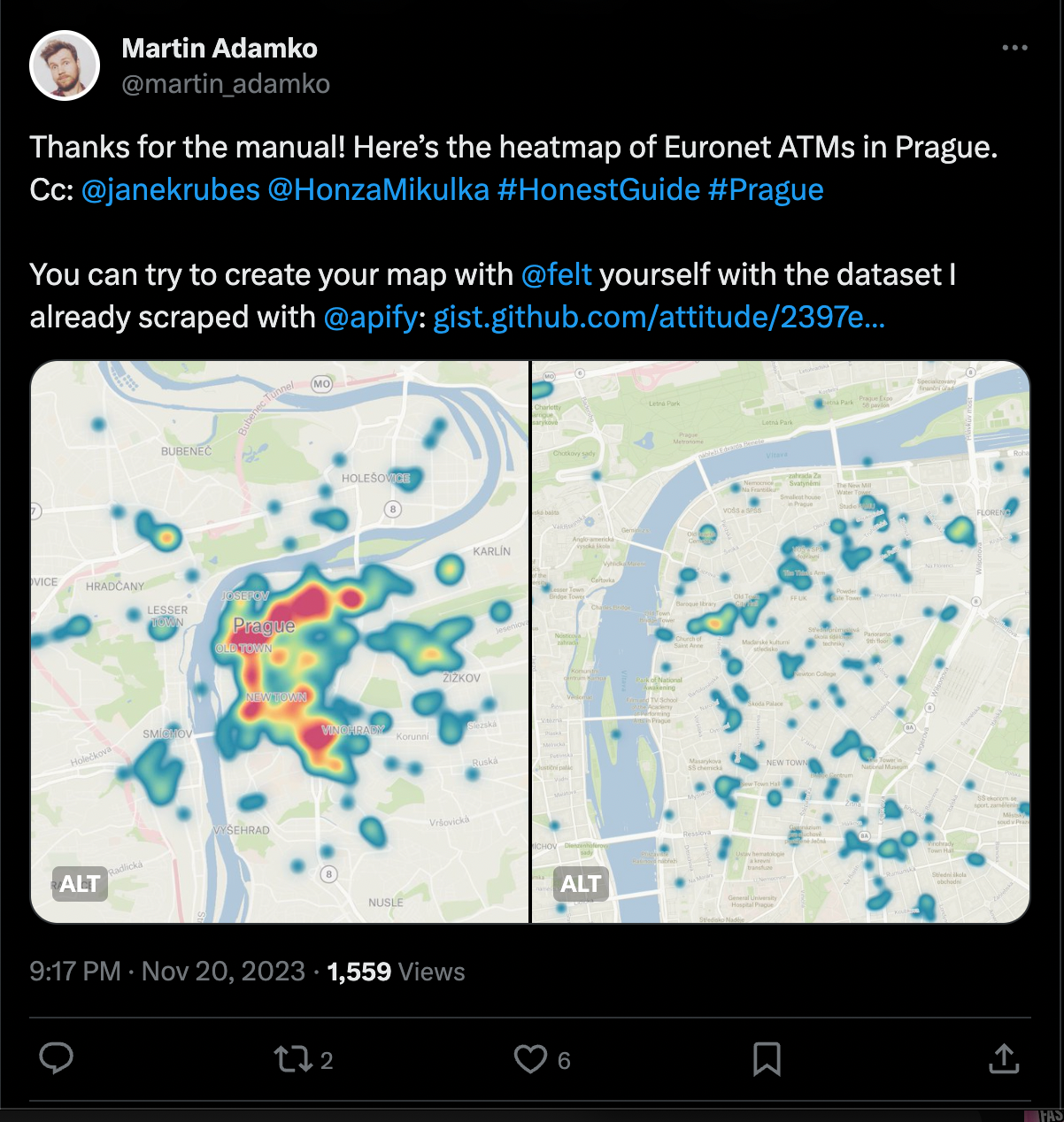
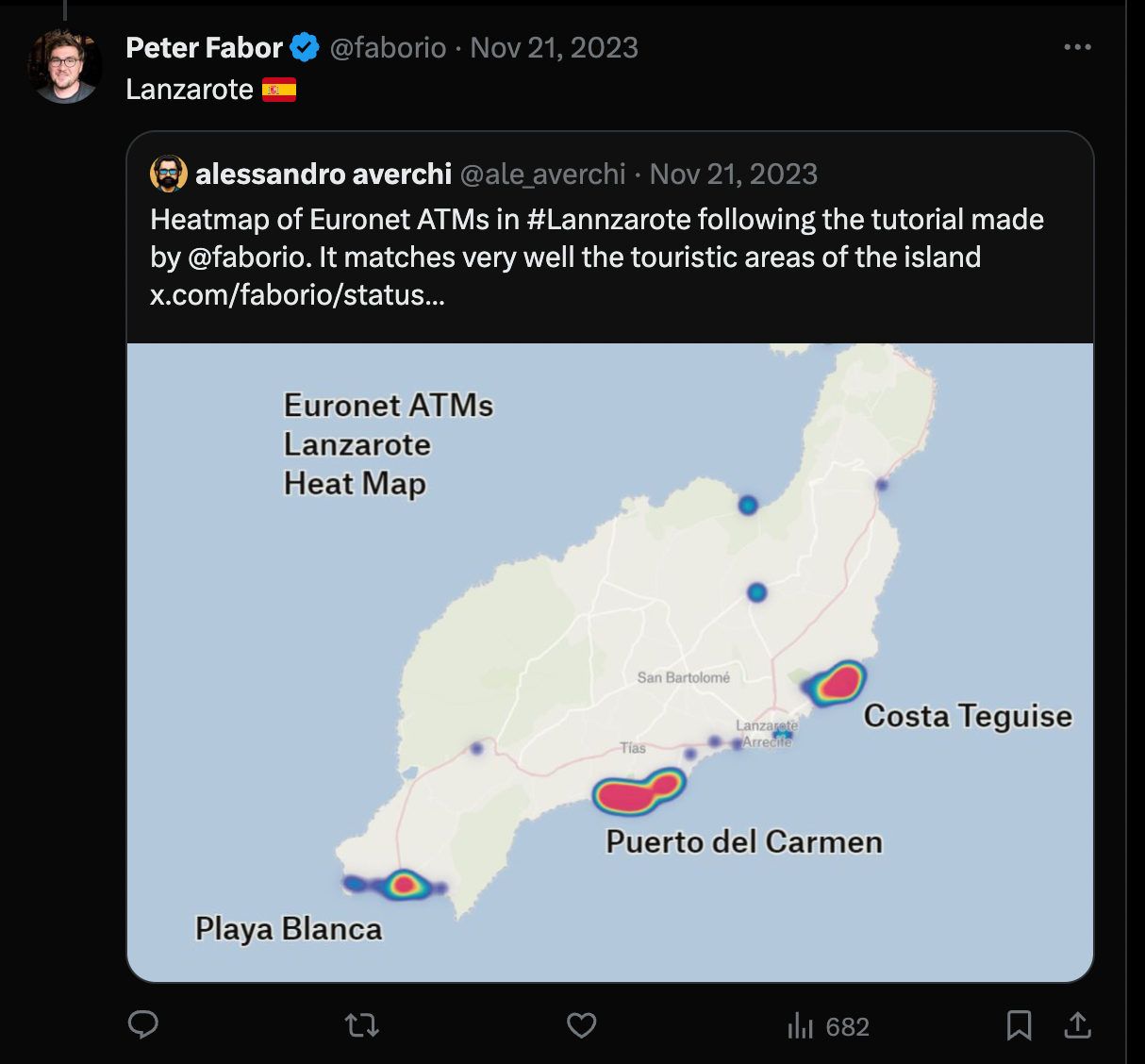
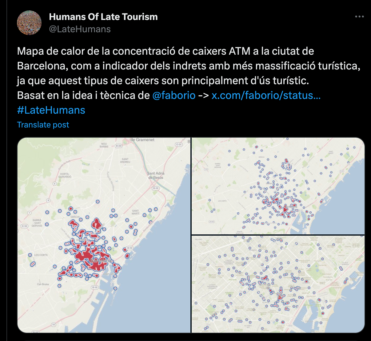
After Peter published a second tweet featuring a tutorial, more people chimed in with their maps of tourism traps.
🚕 Scraping ATMs to map out areas of gentrification and tourist traps
Euronet ATMs are very strong in Europe in places where you don't have a Euro currency as a primary, with Prague being a prime example. Euronet ATMs are also known across the EU for scams. By obscuring the actual conversion rate, they confuse the user (usually a tourist) into picking to convert their money with the Euronet network instead of converting on their bank's terms. How does the ATM know it's a tourist? Very easily — by the card origin, foreign to the country of ATM location.
But what's wrong with a couple of ATMs you might ask? Even if they have high commissions, you can just avoid them.
Well, first of all, they ruin buildings. These ATMs broke several facades of historical buildings in Prague (by being installed there, illegally), with some of them damaged beyond repair. And second of all, a few of them bundled together create a tourist trap and encourage tourism malpractices. For instance, there is a bar/club area in Budapest that has a paid entrance, only serves cash and has Euronet ATMs on its premises exclusively. If you happen to leave the area to get cash around the corner, you'll have to stand in queue and pay the entrance fee again. This doesn't only leave tourists with a bitter experience but also creates extra work for local authorities. Doesn't bother the locals though, because their cards won't be overcharged.
Now that we have some context, back to the map of ATMs. The motivation behind creating it was work-related: most of Peter's customers want to spend their offsites away from the touristy areas. But then what is considered a touristy area? This question kept coming up. Peter gave it some thought and first figured that a higher concentration of Spars, McDonalds’ or Starbucks might mark their area nicely. But that wasn't precise enough. So he had to look for something that didn't belong there. Something so jarring in the local area that it was hard to miss. Something ignored by the locals but very much noticed or remembered by tourists. Like a Euronet ATM.
The idea was very simple and very straightforward. So it only made sense to try and test it on a visual map. Mallorca seemed like a good first choice because Peter was well familiar with the area. So he searched for Euronet ATMs on Google Maps and thought of recreating that data as a separate map. He only needed the right tools to scrape that data (Google Maps Scraper), visualize it (Felt), and tweet about it (Twitter). And here it is:
Tutorial on how to scrape ATM data and make a heat map out of it
Now, before using Google Maps Scraper, Peter thought scraping was something only people who knew how to code could do well and without fuss. If you wanted organized data copied from the website, you had to hire somebody to scrape it. But Google Maps Scraper made it feel like something anyone could make happen. And then double down on it with a little bit of that integration magic — put the data into a spreadsheet, connect with Zapier, update a website, or send it to whoever will work with it, and just create and share interesting stuff – like this ATM map.
📚 7 more interesting cases of appying Google Maps data
- 10 reasons tourists hate European landmarks (according to data from Google Maps)
- Scraping Paris bakeries using Google Maps API
- How to find the cheapest gas prices in your area
- How to scrape Area 51
- How to build a 15-minute city: a question answered by map data
- Top 20 vegan restaurants in Lisbon (according to data)
- Top 20 best and cheapest restaurants in Lisbon, Portugal (according to data)


